
Context: Operational Digital Baseline
digital twin case studies
Digital Twin for Aquaculture: REVER & Yadran Case Study
How REVER Digital Twins used Prevu3D to digitalize 18+ salmon facilities, eliminating costly site visits and delivering audit-ready compliance documentation.
Unlock Case Study

the challenge
Without 3D Digital Twin
- No accurate as-built documentation across any facility
- Outdated 2D drawings causing costly build errors
- Every site visit required flights, vehicles, and boat transfers
- No spatial data to prove regulatory compliance
the benefits
With a 3D Digital Twin
- Measurement-ready 3D models accessible from a browser, not a boat
- Engineering decisions made from the platform — not a 1–3 day trip
- Design conflicts caught before construction, not after
- Audit-ready compliance documentation for offshore concessions
Get Instant Free Access to the Digital Twin for Aquaculture: REVER & Yadran Case Study case study
No Baseline. No Documentation. No Way to Know What You Own.
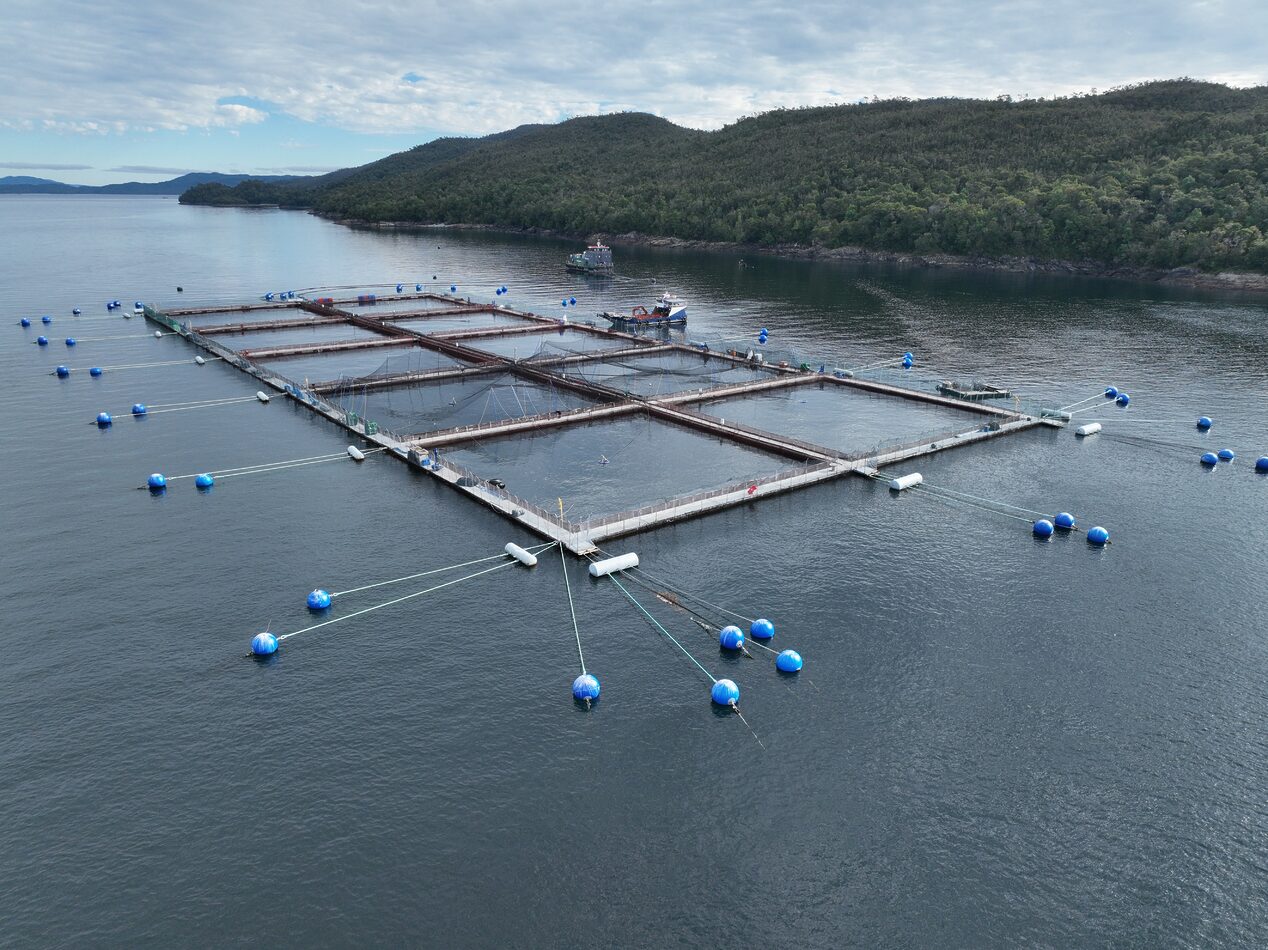
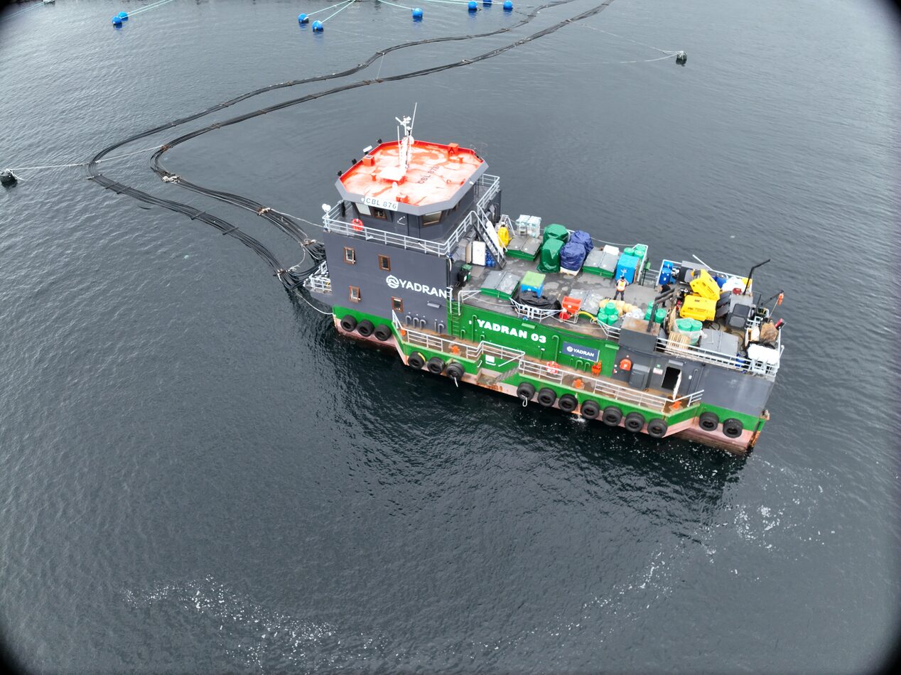
Yadran, one of Chile’s leading salmon producers, operates a geographically dispersed infrastructure spanning freshwater hatcheries (piscicultúras), open-ocean grow-out centers, and a network of pontoons; floating operational platforms scattered across remote southern Chilean waters.
When REVER first engaged with Yadran in 2022, the business had no accurate as-built documentation of its own facilities. That gap carried real consequences across three dimensions:
Design risk: Workers had completed a build-out on one of the salmon pontoons following 2D design drawings, only to discover afterward that the as-built conditions were radically different. Pipes blocked walkways. Door heights were non-compliant. Operators were ducking and squeezing through their own infrastructure. No one had caught it because there was nothing to check against.
Operational cost: Every time an engineer needed a measurement or a site review, the trip required flights, ground vehicles, and boat crossings. Technical staff visits typically ran 1–3 days. For a single measurement question, that meant roughly 72 hours of logistics before any actual work could begin.
Compliance exposure: A regulatory update (Resolution 1821) required salmon operators to prove all offshore infrastructure sat within licensed concession boundaries. Without spatial documentation, Yadran had no way to demonstrate compliance.
Three Phases of Digitalization: From Pontoons to Open Ocean
Working with Yadran over approximately three years, REVER developed an end-to-end digitalization program using laser scanners, drones, and Prevu3D’s RealityPlatform™. The program unfolded in three connected phases, each turning a new layer of Yadran’s hard-to-reach infrastructure into an accessible, measurement-ready operational baseline.
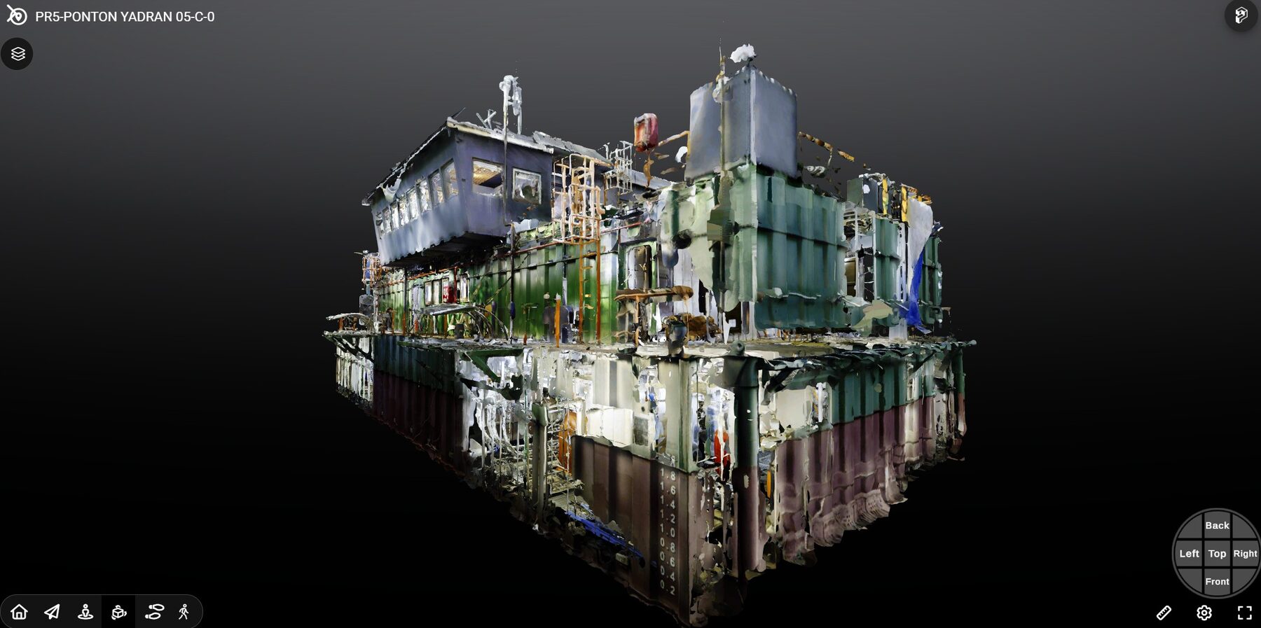
Phase 1 — Pontoons: Floating Platforms, Finally Documented
With no design documentation available, REVER scanned each pontoon using terrestrial laser scanners.
The resulting point clouds were processed and published to Prevu3D’s RealityPlatform™, giving Yadran’s engineering team a navigable, measurement-ready model of every interior space, accessible from a browser, not a boat. In total, more than 18 pontoons were fully digitalized.
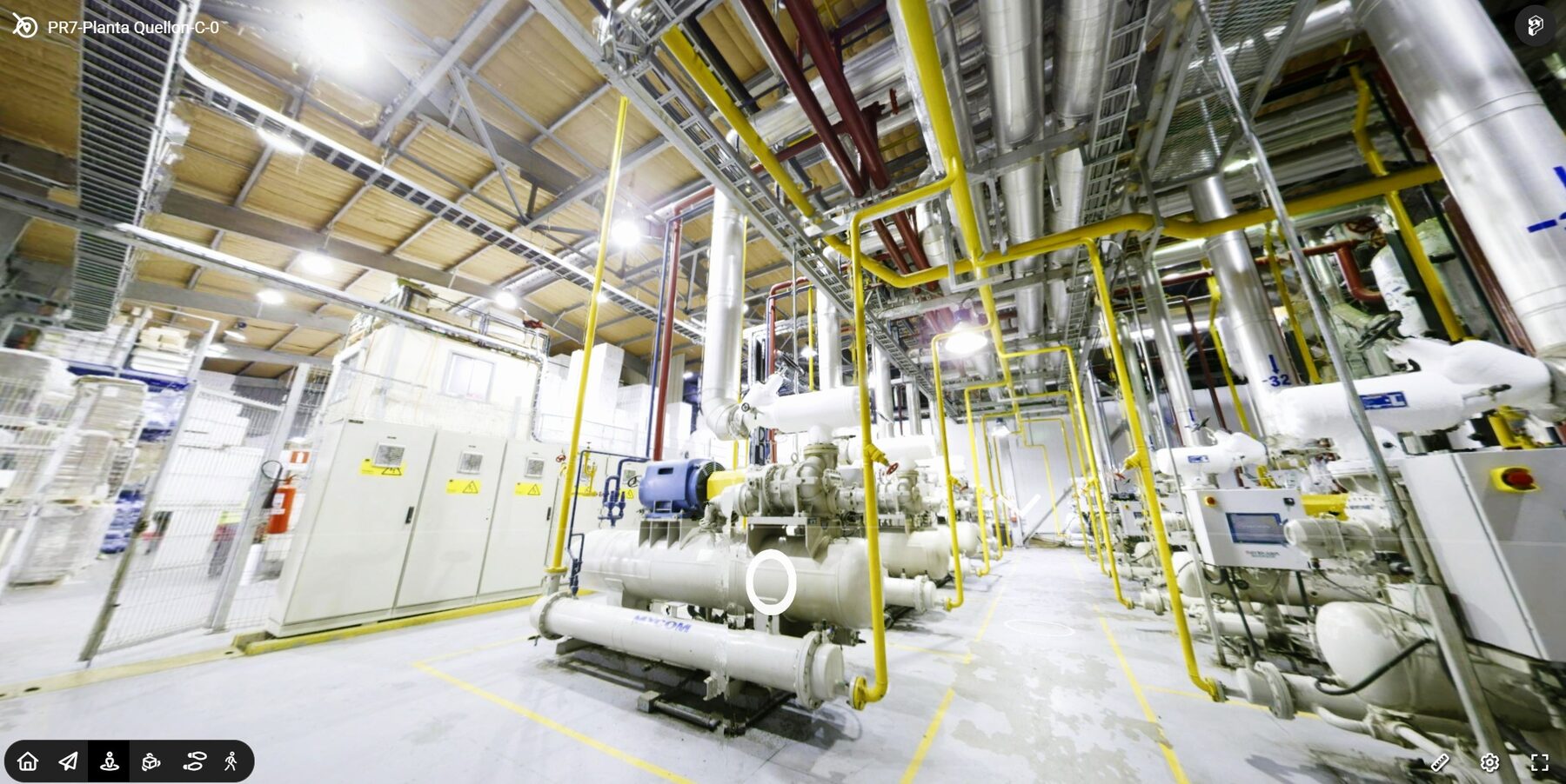
Phase 2 — Freshwater Hatcheries: Complex MEP, Captured with Precision
As Yadran’s needs expanded, REVER extended the same workflow to three large piscicultúras, industrial facilities housing salmon at various growth stages, complete with pipe networks, pumping systems, and climate control infrastructure.
These environments required high-fidelity MEP capture to support downstream renovation planning.
With accurate as-built models now in the platform, engineers could identify improvements to clear heights, pipe routing, and equipment placement before construction began, not after.
Phase 3 — Open-Ocean Centers: Compliance, Georeferenced
Resolution 1821 required Yadran to verify that all offshore installations (pontoons, cage arrays, subsea pipes) were positioned within their legally designated concession perimeter.
Non-compliance carried financial penalties. REVER deployed drones over each grow-out center to capture orthophotographic surveys at scale, generating georeferenced site maps that overlaid concession boundaries, pontoon positions, and cage coordinates in real spatial dimensions.
For the first time, Yadran had audit-ready compliance documentation.
They had no digital baseline for any of their infrastructure. Every measurement, every renovation decision, every compliance check required someone to travel by plane, land, or boat. Our job was to give them a platform where the answer already exists.
— Pedro Briceño, Project Manager, REVER Digital Twins
The Result: an Operational Decision Platform, Not Just a Viewer
Prevu3D’s RealityPlatform™ served as the central operational layer across all three project phases; the environment where raw scan data became actionable context that engineering teams could actually use.
Once data was captured in the field, processed, and published, Yadran’s team could navigate any facility in 3D, pull precise measurements, and review asset conditions without leaving the office.
The key shift: questions that used to require a 1–3 day trip now had answers that already existed in the platform. Engineers could extract dimensional data, review clearances, and pass information to supervisors and project leads, all from a browser window.
A Single Portal for All Project Data
REVER deployed Prevu3D’s public iFrame embed capability to build a custom web portal that aggregated all project data—3D models, documents, orthophotos—in a single interface.
No separate logins. No file downloads. No switching between platforms.
Any authorized team member could navigate the 3D environments in-browser without a dedicated account or software installation.
The results organized across four outcome areas:
Cost & Time
Technical site visits that previously consumed 1–3 days of logistics (flights, ground transfers, boat crossings) were replaced by browser-based access to the platform. Measurement questions that required a full travel cycle now had answers in minutes.
Engineering Speed
During renovation planning, Yadran’s engineering team used 3D models as a working reference for cross-sections, clearance measurements, and zone annotations. Specific improvements were identified across all digitalized assets: clear floor-to-ceiling heights, pipe and duct routing, and mechanical and electrical equipment placement—surfaced in the platform before any construction began.
Risk Reduction
The root cause of the original pontoon renovation failure, acting on 2D drawings with no verified as-built baseline, was eliminated. With accurate 3D documentation in place, engineers could plan modifications against real conditions, not assumptions. Design conflicts that would have been discovered (expensively) during construction could now be caught at the planning stage.
Compliance Readiness
The orthophotographic surveys REVER produced for Resolution 1821 gave Yadran a spatially accurate, audit-ready record proving all offshore infrastructure sat within the correct concession boundaries. This was the first time Yadran had formal spatial documentation at the concession level, a new baseline for regulatory preparedness.
One of the things that really showed us the value of the platform is when someone would ask for measurements inside a specific technical room, and instead of flying out there, the team just opened the model and took the measurement right there. That kind of thing adds up.
— Pedro Briceño, Project Manager, REVER Digital Twins
Expanding the Operational Baseline
With the core digitalization program complete and Yadran under new ownership (acquired by a Japanese firm in early 2025), REVER and Prevu3D are positioned to expand the workflow further.
Key areas of interest:
- RealityTwin™ integration: combining orthophotos, pontoon mesh models, and cage geometry into a unified spatial environment; a single digital twin representing an entire open-ocean farming center, navigable from one interface.
- Inspector integration: REVER’s proprietary inspection tool generates video and point cloud outputs that the team plans to bring into the Prevu3D platform for consolidated asset inspection workflows.
- Sector expansion: building on the Yadran methodology to serve mining and other industrial clients managing remote, geographically dispersed assets with similar documentation needs.
Yadran’s story is a proof point for any industrial operator managing hard-to-reach assets: a structured reality capture program built on Prevu3D can close the information gap, turning dispersed physical infrastructure into a remote-accessible operational baseline that engineering, compliance, and project teams can act on without getting on a plane.
about The partner
REVER Digital Twins
REVER Digital Twins is a Chilean technology firm specializing in reality capture, inspection, and digital twin services for industrial clients. Their team combines laser scanning, drone photogrammetry, and advanced visualization platforms to deliver precise as-built documentation and spatial intelligence at scale. REVER is an authorized reseller and implementation partner of Prevu3D in Latin America.
about us
Prevu3D
Prevu3D is the operational as-built platform for industrial teams—turning reality capture into a connected 3D environment that engineering, operations, and compliance teams can act on from anywhere. Built around three pillars of Capture, Manage, and Connect, the RealityPlatform™ transforms scan data from any source into a navigable spatial environment that connects directly to the tools teams already use: CAD, BIM, ERP, PLM, and IoT systems via RealityConnect™.