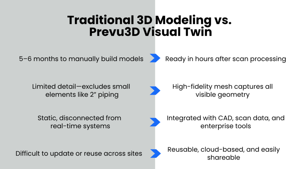
Challenges
- Manual 3D modeling took up to 6 months for detailed industrial sites
- Small piping and critical details often omitted due to time constraints
- Static, siloed documentation limited collaboration and reuse
Benefits with Prevu3D
- Mesh models delivered in 3–7 days, ready for immediate use
- High-fidelity textured meshes capture full site detail, including <2” piping
- Interactive, cloud-based models enable cross-team access and annotations
Challenges
Manual 3D modeling took up to 6 months for detailed industrial sites
Small piping and critical details often omitted due to time constraints
Static, siloed documentation limited collaboration and reuse
Benefits from Prevu3D Technology
- Mesh models delivered in 3–7 days, ready for immediate use
- High-fidelity textured meshes capture full site detail, including <2” piping
- Interactive, cloud-based models enable cross-team access and annotations
+Reality and Prevu3D Enable Immersive Site Insight for Major Italian Energy Operator
Overview
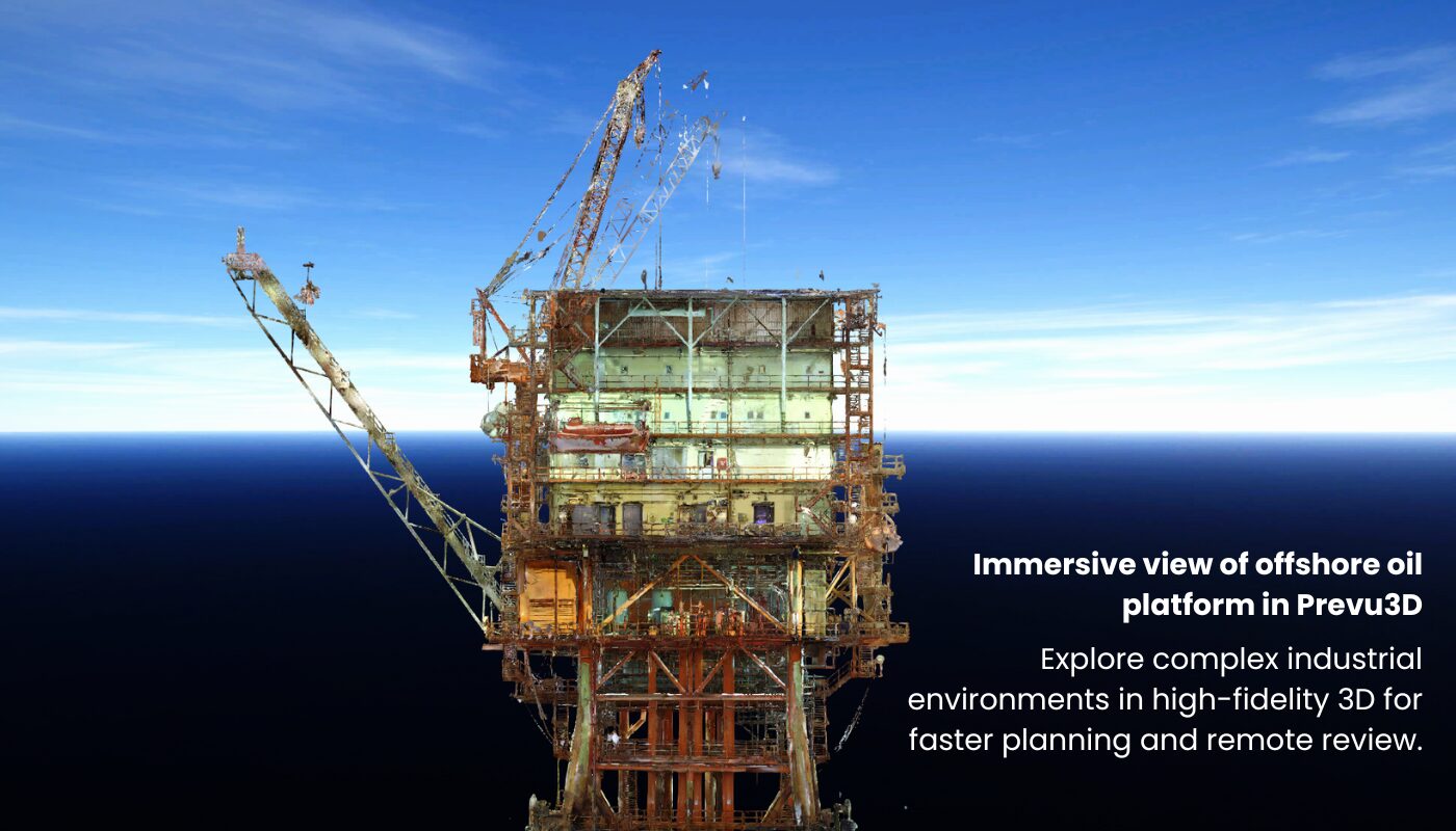
In a high-stakes oil & gas environment, fast access to real-world spatial context is critical for safe, efficient operations. A major Italian oil company worked with +Reality and Prevu3D to streamline operational planning and asset management across a complex network of offshore and onshore facilities.
Leveraging laser scanning and mesh-based visual twin technology, the project delivered a fully immersive, highly accurate 3D environment that accelerated collaboration, improved design workflows, and reduced project overhead.
Partner Spotlight: +Reality
+Reality, founded in 2024, specializes in industrial laser scanning and immersive 3D environments for Italian facilities. With over 20 years of experience in metrology and technical surveying, founders Giancarlo Russano and Riccardo Panichi launched +Reality to meet growing demand for visual, real-time access to field conditions.
Their partnership with Prevu3D allows +Reality to offer intuitive, scalable digital twin solutions tailored to brownfield industrial realities.
We don’t just deliver data—we build partnerships,” says Giancarlo Russano, CEO at +Reality. “Our clients know they can count on us to tailor solutions to their operational reality, not the other way around.
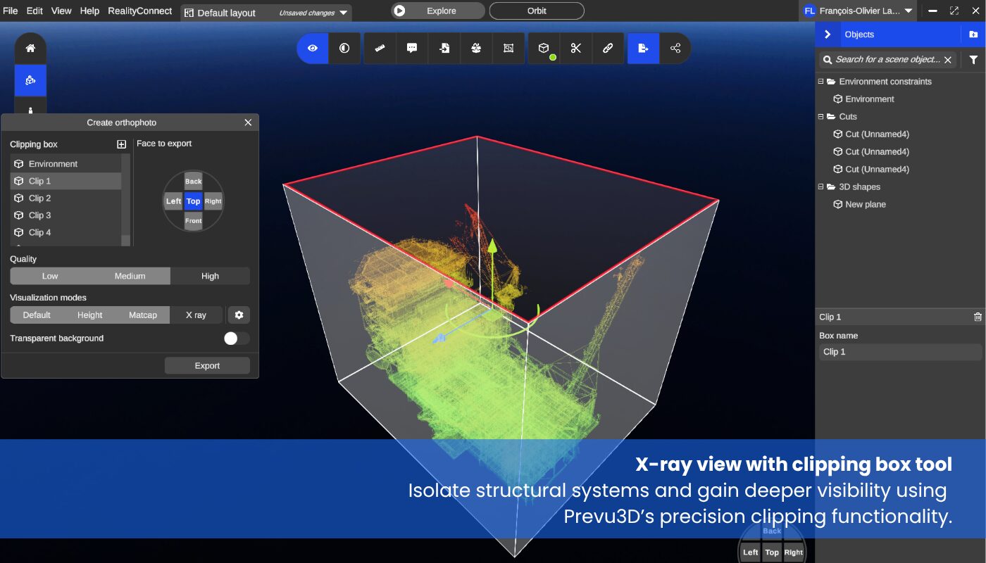
Prevu3D Technology, Bringing Visual Context to Your Assets
Prevu3D enables teams to manage and visualize point clouds, meshes, CAD, and enterprise data in a single interactive environment. In this project, its mesh-based approach provided a rapid, cost-effective alternative to traditional modeling, while preserving the spatial accuracy needed for shutdown planning, inspections, and documentation.
Visual Twin Solutions for Industrial Teams


Challenge
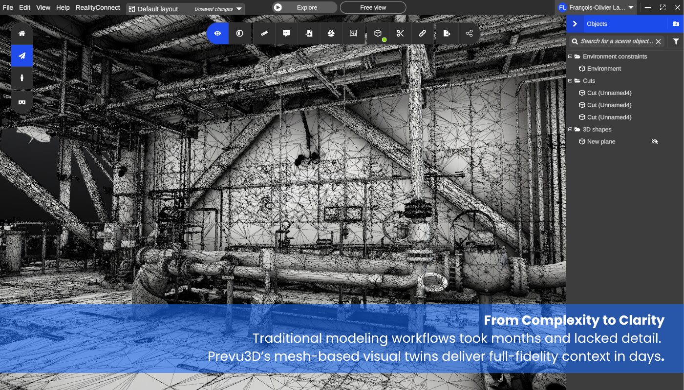
The client needed a visual twin solution to support engineering and operations across complex onshore and offshore infrastructure—without interrupting active site activity. While laser scanning had become a standard first step, their existing documentation workflows relied on manually building 3D models from point clouds.
This process typically required up to 5–6 months of modeling effort, depending on the level of detail—often omitting smaller assets like sub-2” piping due to time and cost constraints. The approach was not only labor-intensive, but also limited in visual fidelity and difficult to scale across departments.
The project required a faster, more accurate, and cost-effective alternative—one that could deliver a complete picture of the facility while accelerating access to usable insights.
Solution
To meet the client’s requirements without disrupting active operations, +Reality deployed a team of laser scanning specialists across two industrial sites. The onshore plant was captured over 20 working days, while the offshore site—despite its logistical complexity—was completed in just 8 days.
Using high-precision terrestrial laser scanners, Leica RTC 360, the teams captured comprehensive spatial data across multiple zones. Once acquired, the data was processed through Prevu3D’s RealityPlatform to generate textured mesh models of each facility. The onshore mesh was completed in 1 week, and the offshore mesh in just three working days, delivering near-instant visibility into complex environments.
The output, exported in FBX format, was integrated directly into the client’s Cadmatic software, enabling engineering and operations teams to work within an interactive, high-fidelity 3D environment. Unlike traditional 3D modeling—which could have taken months to replicate even a fraction of the detail—the Prevu3D mesh captured the entire site with remarkable accuracy and speed.
Working on a live oil & gas site always comes with challenges,” says Giancarlo Russano, CEO at +Reality. “But our approach—combining field experience with agile communication—allowed us to capture the data efficiently and deliver a solution that exceeded expectations.
This mesh-based workflow gave stakeholders an immersive, navigable view of their facilities within days—enabling faster project planning, safer decision-making, and improved collaboration across disciplines.
Project Results
- Accelerated Turnaround
Full site scans were completed in 8–20 days, and textured mesh models were delivered in 3–7 working days—dramatically reducing the typical 5–6 month 3D modeling timeline. - High-Fidelity Spatial Context
Prevu3D’s textured mesh captured rich site detail, including complex piping geometries often excluded from manual modeling, providing teams with an accurate, immersive reference environment. - Cross-Functional Collaboration
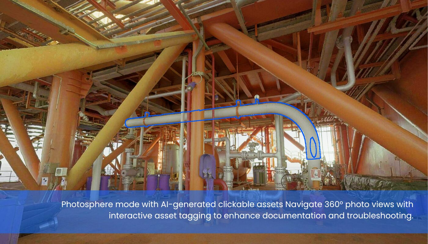
Teams across engineering, operations, and maintenance could remotely navigate, measure, and annotate the site from any location—improving coordination and reducing site visits. - Cost and Effort Reduction
By eliminating the need for manual model creation, the project reduced both modeling man-hours and delivery timelines—enabling faster decision-making and project execution. - Seamless Integration
Mesh outputs in FBX format were imported directly into Cadmatic, allowing engineering teams to continue design work without conversion delays or compatibility issues.
Client feedback was overwhelmingly positive. The visual twin accelerated internal processes, and departments began requesting additional integrations with asset management and maintenance systems.
Future-Ready with RealityTwin
Building on the success of its mesh-based visual twins, Prevu3D is expanding its platform with RealityTwin—a next-generation solution purpose-built for industrial teams working in complex brownfield environments. RealityTwin consolidates scan data (LiDAR, SLAM, drone), CAD, and BIM into a persistent, navigable 3D environment that supports the full lifecycle of facility operations.
Engineers, maintenance technicians, and operations managers can use RealityTwin to plan retrofits, validate designs, conduct model comparisons, and manage spatially-linked asset data—all within a secure, browser-based interface.
Key capabilities include:
- Space Composition
Merge and align multi-source scan data into a unified 3D workspace. Segment zones, overlay time-based layers, and simulate physical changes with minimal manual alignment using control point registration and volumetric blending. - Intelligent Asset Definition
Define, tag, and template equipment using dynamic bounding volumes. Assets remain persistent across scan updates and support attachment of contextual data such as manuals, videos, or IoT feeds—transforming them into maintainable digital records. - Enterprise Integration
Native and API-based integrations with SAP, Aveva, IBM Maximo, AWS SiteWise, and other platforms ensure seamless data flow between RealityTwin and existing systems of record, enabling cross-functional collaboration and real-time decision-making.
RealityTwin combines visual accuracy, semantic structure, and enterprise connectivity to reshape how industrial facilities are planned, updated, and maintained at scale.
Advance Your Digital Twin Journey
Discover how immersive 3D environments can evolve your operations—from planning and maintenance to enterprise integration.